

- Shared Stewardship NC |
- Maps |
- North Carolina Wildlife Quick Start Map
North Carolina Wildlife Quick Start Map
Jan 20, 2021
(Last modified Feb 23, 2021)
Created by
Chelsea Leitz
Recommended by Chelsea Leitz
- Description
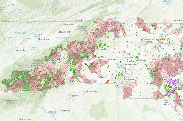
- This map serves as a quick start map to display wildlife activity and priorities in the state of North Carolina.
Layers include:- Administrative boundaries in North Carolina for all NC managed areas, as well as the National Forests boundaries.
- 2015 NC State Wildlife Action Plan - HUC 12 Priorities
- Prioritizing Road Segments for Wildlife Crossings (check the box to turn on layers in map)
- Large Species Model
- Small Species Model
- Location
- Credits
- USFS
- Use Constraints
 This work is licensed under a Creative Commons Attribution 3.0 License.
This map is visible to everyone
About the Map Author
Chelsea Leitz
Regional Inventory, Monitoring, Assessment and Climate Change Coordinator with USFS
I am a member of the Planning Unit staff area at the Regional Office in Atlanta for the USFS. From August - November 2019, I detailed at the National Forests in North Carolina Supervisor's Office in Asheville as the All Lands Data Program Manager.